Please share your resources for planning hiking tours that include an SAC (T1-6) rating!
Bonus points if they include a search function.
Any language is welcome.
Thank you in advance!
If we get an abundance of resources, I will keep a list in this post
hikr.org is for sure the best free resource for small tours (1-3 days) if it is about getting ideas and descriptions.
Otherwise you have the SAC/DAV for mountaineering in the alps (not free anymore though).
Maps : I used osm in basemap with my gpsmap 62, now I switched over to the swisstopo map on the phone in Switzerland, but still using basemap/osm to create .gpx files for swisstopo if needed. There might be better tools now - just got used to it. Didn’t do any stuff outside of Switzerland since I ditched my gpsmap - just had outdoor active as a back up on my phone.
Schweizmobil is not the best for mountaineering tours, but for mountain hiking tours or long distance trails, it is pretty cool (especially the hotel POI list for long distance tours).
Otherwise I am on the ultralight trekking forum in Germany to get gear ideas - especially for European stuff. Ultraleicht Trekking Forum, and it already helped me to get some nice weekender tour in Switzerland, but of course it is more about long distance.
Personnally I am more into ultralight trekking (I am not equipped and not able to do anything above T4 - and some T4 stuff is already pretty borderline for me).
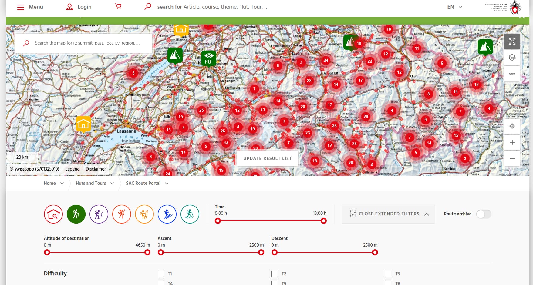
You got all the ways inside (it uses the Swisstopo base), but it is thought for T1-T3 (marked in yellow for T1-T2/red for T3 in their layer). It has even some T4+ stuff (in blue in their layer), and you can plan your own stuff with .gpx export (also on desktop) if you have a paid subscription. Of course the main aim for schweizmobil “free” is T1-T3 tours which are readily available (the numbered ways), but the paid subscription is pretty powerful (and pretty cheap - 35 CHF/y). Especially you can switch between toggled routing and wayless inside the same route (you must create different tracks for each section), which most application can’t do in my knowledge.
My problem with the swisstopo app is that the web tool is not nice for planning and exporting .gpx files, and the phone app is too fiddly for planning for me (did not tried it on desktop/tablet though - should do it though).
Here I would like to add what amazing tool we got here for free (paid via taxes of course) with swisstopo and schweizmobil, which even informs you about closed ways etc.
Besides the already mentioned resources, I also like Komoot. Great to find routes near you (including photos) and you can filter by difficulty (although they use a different scale) and lenght.
From the menu left of the map, you can filter by parameter. Snow is one but I’d also use temperature since there are way more stations measuring it.
You can then pick your station and follow the guided steps to download either the data for the past year or since they’re automatically collected (longer time series). Rinse and repeat for the areas where you’d be interested to go hiking.
If the temperatures went near zero or under it, there has been a chance of snow in the area said month of said year. I’d use daily data in order to have a usable resolution (monthly data will miss the occasional episodes which are what you’re after if you’re planning a hike in October).
It’s a bit of a tedious process (you can otherwise automate it and create maps if you’re in the mind and follow the steps from the OpenData portal) but if you’ve singled out a few hikes you’re wanting to do, as you seem to have, it doesn’t take that much time either.
Cool dataset!
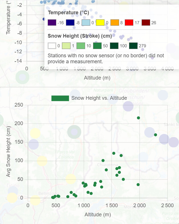
I gave it a shot at automated retrieval and built Swiss Temperature & Snow Map which lets you select a date, and plots the average of that day on the 2010-2019 decade (say all January 1st as default when you load the site - ignore the slider saying 2020), with temperature as main dot and snow height as stroke around the dot (you can click any dot and see real values). This is for any automatic measurement station I found on the Meteoschweiz archive (iterated through the list).
As data is sometimes a bit sparse, but altitude is the main factor, I also made aggregate plots on the right side. Was a fun tiny project (may be a bit slow, not optimized in any way).
I don’t plan to develop this much, was waiting since a while for a cool excuse to learn API/url calls in python and a bit of vibe coding…
Feel free to download the source jupyter notebook at Swiss Temperature & Snow Map and play with it.
I currently fetch temperatures 5cm above ground ‘tre005h0’, with a fallback to 2m above ground for more datasets ‘tre200h0’, and snow height ‘htoauths’.
The list of available parameters is https://data.geo.admin.ch/ch.meteoschweiz.ogd-smn/ogd-smn_meta_parameters.csv so feel free to edit and fetch hourly precipitation ‘rre150h0’ for example (or even feed the script in a LLM and ask it to do so)… Just need a few python libraries, and starting a local server (instructions at the bottom of the notebook)
Made the plots a tiny bit smaller though as this is easy (might require a F5 / force refresh as this is CSS based). It is indeed temp vs altitude to guess where the daily mean zero degree lies.
Mit dem Lesen und der Teilnahme an diesem Forum bestätigst du, dass du die Forum-Richtlinien gelesen hast und damit einverstanden bist sowie den Haftungsausschluss auf http://www.mustachianpost.com/de/ akzeptierst.